Land & Water · El Olivar · San Isidro · LimaPublished 22 August 2026
Why Are El Olivar’s Olive Trees Still Planted in Straight Lines?
Because El Olivar was an agricultural grove before it was an urban park. The old planting geometry survived while twentieth-century San Isidro grew through and around it.
Walk through El Olivar and the park initially behaves as a park should.
Paths curve.
Lawns open and close.
Streets interrupt the grove.
Benches, houses, and apartment buildings establish the scale of contemporary San Isidro.
Then the trees begin to line up.
Look across them rather than at them and another landscape appears: olive trunk behind olive trunk, resolving into remarkably straight rows.
The paths bend.
The trees do not.
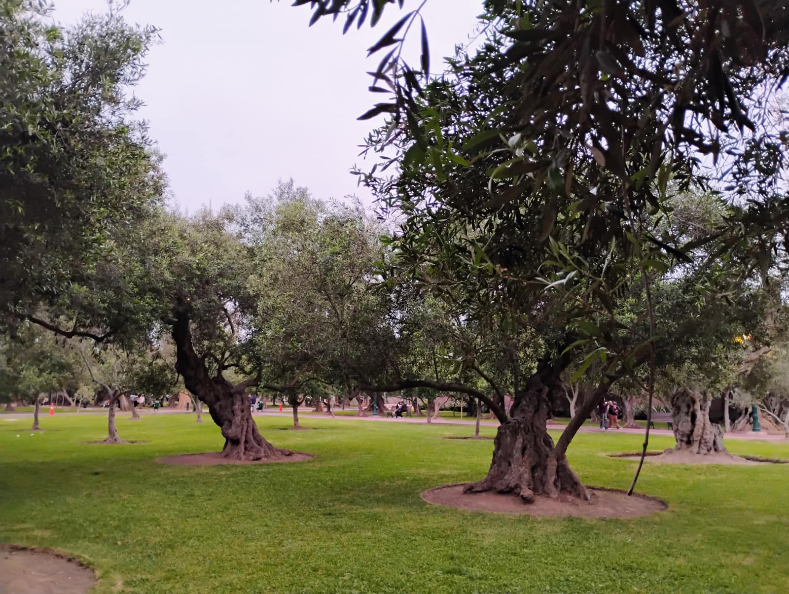
El Olivar, San Isidro, LimaCarlo BresciaCC BY-SA 4.0
The short answer
The rows are agricultural because El Olivar was an agricultural landscape before it became an urban park.
The surviving trees are remnants of a productive olive grove.
When the San Isidro area was transformed into a garden-city development in the early twentieth century, the old landscape was not simply cleared and replaced with a newly designed park.
Planning incorporated important elements of what was already there.
Research on the transformation of El Olivar shows that the urbanization used traces of the hacienda's existing irrigation system and worked through a landscape already structured by agricultural production.
That is why the park contains two geometries at once.
One belongs to the grove.
The other belongs to the city that arrived later.
Before the park, there was a productive landscape
It is easy to read an old urban grove backward.
Centuries-old trees inside a prosperous residential district begin to look as though they were preserved because they were always picturesque.
But olive trees planted in repeated rows are not primarily picturesque objects.
They are agricultural infrastructure.
Spacing matters because trees need access to light, water, labor, and harvest.
Rows make land legible and workable.
The exact historic planting pattern of every surviving part of El Olivar still needs more detailed reconstruction, but the larger point is not ambiguous: the olive grove predates the modern park.
The park inherited its trees.
San Isidro arrived in the twentieth century
The decisive urban transformation came in the early 1920s.
Research by urban historians places a projected plan for San Isidro by the sculptor and planner Manuel Piqueras Cotolí in October 1920, followed by the definitive notarized plan in 1921.
The development was conceived within the garden-city ideas circulating at the time.
But this was not an empty tract awaiting design.
The new urban form encountered an existing hacienda landscape.
A detailed study of El Olivar by Marino Ruiz and Manuel Palomino shows how the transformation took pre-existing elements, including traces of irrigation channels, as points of departure.
The city was laid onto an agricultural substrate.
Some structures disappeared.
Some changed function.
Some remained visible.
The trees are the most obvious survivors.
In 1922, the grove was already becoming something else
A real-estate advertisement published in the Lima magazine Mundial in April 1922 captures the transition unusually well.
The new San Isidro was being sold partly through qualities inherited from the countryside: gardens, shade, old trees, and the promise of El Olivar as a public park.
That is more than a planning detail.
It marks a change in value.
An olive grove had been valuable because it produced.
Now the presence of the grove could also make surrounding residential land desirable.
The same trees were being inserted into a different economy.
Agricultural landscape was becoming urban environment.
The grove did not disappear when its function changed
This is what makes El Olivar visually unusual today.
In many cities, earlier productive landscapes survive only as street names, cadastral boundaries, or buried infrastructure.
Here, living organisms survived the transition.
The agricultural matrix remains visible because individual trees continued occupying places established before the contemporary park experience existed.
Later paths did not need to obey that matrix.
Roads, houses, lawns, and pedestrian circulation could bend around and between what survived.
From ground level, the two systems can be difficult to see simultaneously.
Stand in the right place, however, and the older one suddenly resolves.
A winding path crosses a straight row.
The park briefly becomes a grove again.
Water may be the less visible continuity
The trees are the part of the earlier landscape that anyone can see.
Water is harder.
Agriculture on the Peruvian coast cannot be understood only through trees and soil. Irrigation preceded the Spanish olive and formed part of the productive landscape into which imported crops entered.
The twentieth-century transformation of San Isidro likewise did not begin with a featureless surface.
Research on El Olivar points to existing irrigation-channel traces as part of the landscape encountered by the urban plan.
Reconstructing those water systems more precisely is one of the project's continuing research tasks.
The visible rows provide the clue.
The less visible infrastructure may explain much more.
A 1943 aerial view makes the overlap clearer
Historical aerial evidence becomes particularly useful because the pattern is easier to read from above than from inside the grove.
Research on El Olivar reproduces a 1943 aerial image alongside planning material and later urban form.
The image belongs to a San Isidro already undergoing urban transformation, but it helps reveal the relationship between the surviving grove and the city growing through it.
For publication on this site, the project is tracing the original archival source and reproduction rights before using that image directly.
That distinction matters.
A historical image can be evidence without automatically being a reusable website asset.
What we can say with confidence
El Olivar existed as an agricultural olive grove before the modern urbanization of San Isidro.
The early twentieth-century development incorporated significant parts of that inherited landscape rather than starting from an empty site.
Research on the transformation of the area documents the relationship between the old hacienda landscape, irrigation traces, Piqueras Cotolí's planning, and the later garden-city environment.
A 1922 development advertisement already presented the old grove as an amenity of the new residential district.
The straight rows visible today are therefore not a landscaping trick designed for the park.
They are traces of an earlier productive geometry.
What remains uncertain
How much of the precise row pattern visible today can be mapped directly onto documented historic planting plans?
That requires better primary cartographic evidence.
Which surviving trees occupy their original agricultural planting positions, and which were replaced or added later?
The grove has undergone centuries of loss, replanting, conservation, and urban intervention. Individual-tree continuity should not be assumed from the age of the landscape as a whole.
How exactly did the older irrigation system shape the surviving urban form?
The connection is documented at the planning level, but the project is still reconstructing the network in enough detail to map it responsibly.
Which historical plans and aerial images can be reproduced publicly?
Several have been located through secondary research. Original archive holders and reuse permissions are still being traced.
For now, the most important evidence remains available without a map.
Stand among the trees.
Ignore the path for a moment.
Look across the grove.
Source trail
Historical and planning research
Marino Ruiz & Manuel Palomino, “Transformaciones del bosque El Olivar: la ruta hacia la conservación del paisaje” (2021).
The central current study for the grove's transformation, irrigation traces, Piqueras plan, historical advertising, and aerial evidence.
Wiley Ludeña Urquizo, research on the urbanization of San Isidro.
Reconstructs the early planning history from Moreyra-family and urban records, including the 1920 projected plan and 1921 definitive plan.
Primary source
Mundial, Año III, no. 99, 7 April 1922, p. 37.
Period advertisement for the San Isidro development showing how the inherited landscape was being reframed as part of a new residential environment.
Institutional source
Municipalidad de San Isidro / Gobierno del Perú, Bosque El Olivar.
Useful for the present-day status and institutional description of the grove.
Gobierno del Perú, Bosque El Olivar
Visual research
Historical planning material and a 1943 aerial image have been located through published research.
The project is tracing the original archive holders and reproduction rights before displaying those materials directly.
Research status
The next stage is to reconstruct the original grove geometry and irrigation network from primary plans, aerial photography, and property records so that the relationship between agricultural rows and later urban form can be mapped rather than merely described.
About sourcing, uncertainty, and corrections: Research Standards